Geographic Information System & Remote Sensing
"By:"Mostafa SadeghnejadGeographic Information System & Remote Sensing
"By:"Mostafa Sadeghnejadدرباره من
 اینجانب مصطفی صادق نژاد کارشناس ارشد GIS و سنجش از دور و دانش آموخته مهندسی منابع طبیعی(مرتع و آبخیزدازی)دانشگاه تهران میباشم.مشاور در امورGIS- سنجش از دور- آبخیزداری-نقشه برداری-برنامه نویسی-تفسیر تصاویر ماهواره ای میباشم.برای ارتقاء و همکاری و هرگونه فعالیت علمی پژوهشی دست همه را به گرمی میفشاریم.دانش را برای آنکه خواهان نیست،عرضه مکن (کنفوسیوس)-ترس از انتقاد،موجب مرگ نبوغ میشود(ویلیام سیمز).انتقادات و پیشنهاد خود را به ایمیل زیرارسال نمایید.
پست الکترونیک : sadeghnejad@ut.ac.ir
ادامه...
اینجانب مصطفی صادق نژاد کارشناس ارشد GIS و سنجش از دور و دانش آموخته مهندسی منابع طبیعی(مرتع و آبخیزدازی)دانشگاه تهران میباشم.مشاور در امورGIS- سنجش از دور- آبخیزداری-نقشه برداری-برنامه نویسی-تفسیر تصاویر ماهواره ای میباشم.برای ارتقاء و همکاری و هرگونه فعالیت علمی پژوهشی دست همه را به گرمی میفشاریم.دانش را برای آنکه خواهان نیست،عرضه مکن (کنفوسیوس)-ترس از انتقاد،موجب مرگ نبوغ میشود(ویلیام سیمز).انتقادات و پیشنهاد خود را به ایمیل زیرارسال نمایید.
پست الکترونیک : sadeghnejad@ut.ac.ir
ادامه...
دوره ی آشنایی و استفاده از دستگاه GPS بهمراه تهیه نقشه UTM
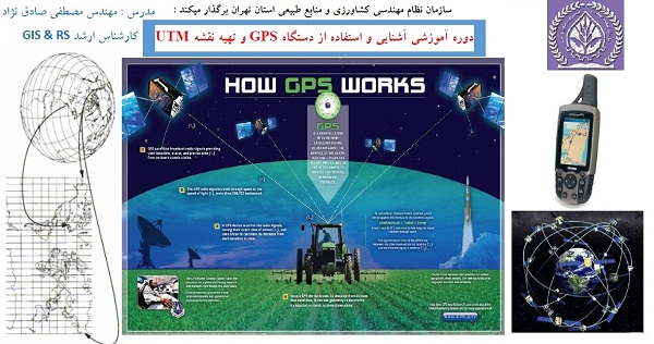
ضمن عرض پوزش به دلیل تاخیر در آپلود فایلهای مربوط به دوره ، در ادامه مباحث و مطالب جهت دانلود تقدیم شما عزیزان میگردد:
پاورپوینت جلسه ی اول : سیستم مختصات و سیستم تصویر از اینجا دانلود کنید
پاورپوینت جلسه دوم : سیستم تعیین موقعیت جهانی GPS از اینجا دانلود کنید
کتاب آموزشی نرم افزار ArcGIS از اینجا دانلود کنید
فایلهای تمرینی کتاب آموزشی ArcGIS از اینجا دانلود کنید
فیلم آموزشی کار با دستگاه GPS از اینجا دانلود کنید
جهت دانلود نقاط برداشت شده توسط دستگاه GPS از اینجا دانلود بفرمایید.
GIS and Agriculture
Use of GIS in Agriculture
Droughts, floods, swarms of insects and poor farming techniques have plagued the agricultural community for centuries. Improvements have been made to insure the safety and gain of crops worldwide and yet these factors and many more continue to make or break individuals and communities affected by them.
Geographic Information Systems are incredibly helpful in being able to map and project current and future fluctuations in precipitation, temperature, crop output, and more. By mapping geographic and geologic features of current (and potential) farmland scientists and farmers can work together to create more effective and efficient farming techniques; this could increase food production in parts of the world that are struggling to produce enough for the people around them. GIS can analyze soil data combined with historical farming practices to determine what are the best crops to plant, where they should go, and how to maintain soil nutrition levels to best benefit the plants.
Many organizations are now implementing GIS systems including the USDA. They use many GIS variations in each of the USDA sectors to best capture what that department specializes in; in recent months, however, the benefit of combining this information has been realized due to the incredible capacity of GIS to transform and combine large amounts of data into a data set. In the United States GIS systems are used by the USDA to protect crops, solve crop issues, and investigate fraudulent claims of crop damage as well as give farmers an easy way to access information about their crops season by season.
Agricultural Geographic Information Systems (AGIS) can map not only topography and crop health, but help solve wider economic issues in municipalities and urban centers that may stem from rural farming practices. Farmers in the States are able to access the GIS data on their lands; a program called CropScape and another called VegScape allows farmers to interact with the data without having a GIS themselves, ask questions and interact with the data as well as provide valuable on-ground data that can’t be gathered via satellite. Jeffrey Bailey, the chief of the National Agricultural Statistics Service’s Geospatial Information Branch, estimates the accuracy of their crop data is in the mid-90th percentile with the added ground data from farmers.
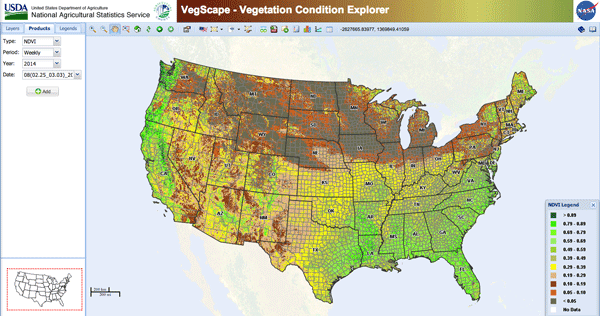
VEGSCAPE (VEGETATION CONDITION EXPLORER) IS THE SATELLITE BASED ASSESSMENT OF PLANT HEALTH ACROSS THE UNITED STATES. A DEEP GREEN COLOR SHOWS AREAS OF STRONG PLANT VIGOR. YELLOW, BROWN, AND GREY SECTIONS MAP OUT POORER PLANT CONDITIONS.
The Agricultural Geographic Information System Laboratory (AGIS) at the University of California, Davis is deeply involved in the advancement of the agriculture/GIS relationship. This AGIS lab researches the effects a watershed area has on soil nutrients, the use and movement of pesticides on crops, mapping water use and availability in rural agricultural areas as well as cities, tracking potential plant diseases, and expanding the GIS capabilities to cover the entire state. In addition to expanding the potential uses of GIS the AGIS Laboratory is dedicated to disseminating the information they gather to local farmers, wineries, and city officials to best help promote healthy change in behaviors that affect the agricultural outputs of California.
The future implications of AGIS are incredible and immense in scope. With the permeation of technology in the global culture today it is possible that in a few years GIS could be available to rural farmers in the developing world to better help them grow crops, feed their families, and produce enough food to ship to neighboring areas. Farmers in severe-weather prone areas (like flood plains or drought zones) would be able to predict what this weather could do to crops, could move fields to better geographic locations, and know how to irrigate based on local water resources and weather patterns. The world food crisis could be alleviated by the use of GIS.
References:
University of California, Davis. College of Agriculture and Environmental Sciences. Department of Land, Air, and Water Resources. Agricultural Geographic Information Systems Laboratory homepage.http://agis.ucdavis.edu/
GIS becomes indispensable for mapping agriculture. GCN. Patrick Marshall. October 18, 2013.http://gcn.com/Articles/2013/10/18/USDA-GIS.aspx?Page=1
NuGIS: A nutrient use Geographic Information System for the U.S. Fixen, Paul E.; Williams, Ryan; Rund, Quentin B. International Plant Nutrition Institute. 2007. http://www.ipni.net/nugis
(http://www.gislounge.com/use-gis-agriculture/)